
The first expeditions to Greenland were primarily scientific in nature. However, they also yielded remarkable discoveries and explorations of the mountain ranges, as well as several ascents. Perhaps the first was the climber J. Payer’s ascent of Payer Spitze (2,133 m) above the Kejser Franz-Joseph Fjord in 1870. Interest in Greenland was then rekindled by Nansen’s crossing of the Greenland Ice Sheet in 1888 from Umivik to Godthab (modern Nuuk).
Historical essay by: Jim Gregson, comments by Paul Walker.
Greenland Ice Sheet
The Greenland Ice Sheet is the second largest ice sheet in the world after the Antarctic Ice Sheet.
The ice sheet covers an area of 1.71 million km², occupying about 80% of Greenland’s territory, and extends from north to south it is almost 2.4 thousand km, and the width in the north reaches 1100 km. The average ice thickness is 2,135 meters. The greatest thickness of the sheet exceeds 3,000 meters. The age of the ice is estimated at approximately 110,000 years.

The ice sheet is located in the center of the island, separated from the sea by a strip of land; in some places, its border is practically on the coast. Greenland’s coastline is heavily indented by deep, long fjords that reach the edges of the ice sheet. The Greenland Ice Sheet is not the island’s only glacier; other isolated glaciers and ice caps are located off the coast.

In the late 19th and early 20th centuries, several more routes were taken across the island’s ice cover. The following event became significant for mountaineering: in 1912, the Swiss Alfred de Quervain, crossing the island from west to east, discovered the region of Schweizerland (Switzerland), which he named so because of its resemblance to the Alpine landscape.
")
British explorer J.M. Wordie led expeditions to northeast Greenland in 1926 and 1929, during which he made the first ascent of Petermanns Bjerg, the highest point in the High Arctic and, as was then considered, “Greenland’s highest mountain.”
")


This is a homemade sailboat that moved across snow and ice using a sail under wind.
The 1930s saw a surge of interest in the mountains of Greenland. Between 1930 and 1932, the British Arctic Air Expeditions, led by Gino Watkins, traveled extensively across the Greenland Ice Sheet and the mountains of the east coast. An attempt was made to climb Mont Forel, and aerial reconnaissance led to the discovery of an area later named Watkins Bjerge; it contained the island’s highest mountains.

Photo from the site: http://www.freezeframe.ac.uk
")


In 1933, the American expedition led by Louise Boyd made a number of ascents of the mountains located north of Petermann’s Bjerg. Then, important discoveries were made by the British expedition of Martin Lindsay, which in 1934 crossed the ice sheet from west to east, determining the exact location of Mount Monarch, which was later renamed Gunnbjørns Fjeld – it indeed turned out to be the highest point of the island. Lindsay then traveled by sled hundreds of kilometers southwest to Ammassalik, opening the approach to the extended ridge of Kronprins Frederik Bjerge.

In 1935, Lawrence Wager, a member of the Watkins expedition, returned to ice-bound east coast to be the first to climb the route from Sødalen and make the first ascent to the summitGunnbjorns Fjeld(3693 m), from which the mountain Lemon Bjerge is visible to the northeast of the fjord Kangerdlugssuaq.
, Greenland")
, Greenland")

Throughout In 1938, a Swiss expedition, including the renowned mountaineer André Roch, traveled through the Swiss region, making the first ascent of Mont Forel (3,360 m), as well as 13 other remarkable first ascents, including Laupers Bjerg, Rødebjerg, and Rytterknægten, thereby drawing the attention of the mountaineering community to the beauty of the region’s peaks.
 and Andre Roch (right) at the summit of Hayden Peak, 1937")
Photo: Aspen Historical Society
In the post-war years, with the expansion of mountaineering opportunities, expeditions to eastern and northeastern Greenland. The expeditions of Lauge Koch to eastern Greenland in 1950–1953, although pursuing scientific goals, included strong climbers, in particular J. Haller and W. Diehl, who climbed many significant peaks in Goodenough Land, Swuess Land, and other areas of Christian X Land. The first ascents of Lauge Kochs Bjerg, Payers Tinde, Hamlet Bjerg, Shackletons Bjerg and Pluto Nunatak were made during this time. Further north, the Barth Mountains and Dronning Louise Land became the testing grounds for the first ascents of the British North Greenland Expedition of 1952–1954.
")

The 1950s marked the beginning of a fruitful development of mountaineering in the region of the magnificent Alpine peaks – Staunings Alps. Expeditions from Norway, Switzerland, Denmark, Austria and Scotland made many first ascents. Thus, in 1954, Haller and Diehl (Haller, Diehl) took the opportunity to make a first ascent of Danmarkstinde (Dansketinde), the highest mountain in the Staunings region – 2930 m, and repeated the ascent of Norsketinde (Stortoppen) soon after its ascent by the Norwegians and Danes. Many expExpeditions flocked to the Staunings Alps in the 1960s, and climbers from various countries made numerous first ascents in this attractive alpine region.
The mountains of Ammassalik, Schweizerland, and the surrounding area of Mont Forel also continued to attract expeditions, with teams from Japan, Switzerland, Sweden, and the United Kingdom achieving significant success. Sad news also emerged: the first fatal accidents in Greenland occurred during a British Royal Navy expedition in 1966, when two climbers died under different circumstances. In 1963, a Scottish expedition to eastern Greenland made a series of ascents in the Caledonian Alps, an area adjacent to the Swiss Alps, while the Swiss, led by S. Angerer, in 1966 climbed impressive peaks on glaciers extending northeast from the enormous Glacier de France.

With the advent of the 1970s, the number of expeditions with mountaineering ambitions increased. However, most of them continued to visit established areas, which led to a rapid increase in climbing skill and technical standards, while new areas were little explored. The expansion of aviation capabilities, primarily due to the opening of an airfield at Kulusuk on the east coast, brought significant changes. European nations – teams from Italy, France, Germany, and Great Britain – dominated the development of mountaineering. The Staunings Alps continued to attract climbers, and interest in the opportunities offered by Kronprins Frederik Bjerge was rekindled. The high peaks near Mont Forel acted as a magnet for some climbers, while others sought technical challenges elsewhere – including the Swiss ascents of Cisdon, Istinde, and Eismeer Jungfrau near the Pourquoi-Pas Glacier in 1966, and the Croatian ascent of Ingolffjeld in 1971. Further north, several groups attempted to reach the inaccessible, unknown regions beyond the Blossville Coast, near Scoresby Sund.
Interest in this region was fueled by two literary sources. Mario Fantin published a book in Italian, “Montagne di Groenlandia,” in which he attempted to cover all expeditions to Greenland up to 1969. In 1971, Donald Bennet described the intensive development of the region of the same name in his book “Staunings Alps.”
In the summer of 1970, Andrew Ross’s expedition sailed on an open-sided boat from Scoresby Sund to Wiedemanns Fjord, then crossed the ice sheet and made a successful first ascent of the formidable peak of Ejmar Mikkelsens Fjeld. In 1972, the second ascent of Gunnbjorns Fjeld was made by a British-Danish team led by Alastair Allan. In the eastern sector of Watkins Bjerge, Brown and Soper from the University of Sheffield (UK) made the first ascent of the high mountain Borgetinde. Another British group began exploring the Roscoe Bjerge area in Liverpool Land.
The first ascent of Borgetinde was made in 1972 by Rod Brown and Nigel Soper from the Sheffield University expedition, and then in 2000 by the British expedition of Nigel Edwards. Before the English group arrived in 2007, another team made a third ascent of Borgetinde, but failed on Ejnar Mikkelsens Fjeld, a bit further south, due to avalanche conditions. The latter, it seems, has only been climbed twice. The first ascent of the 3,308th peak was a tour de force, and at the time it was considered the highest unclimbed peak in Greenland.

A significant event occurred in 1972. The Westminster Expedition to East Greenland, which included Stan Woolley, sailed from Kulusuk to Kangerdlugssuaq Fjord, walked along the Frederiksbjorg Glacier to Lemon Bjerge, and took in the breathtaking alpine scenery first seen by Wager in 1935. In the following years, Woolley also played a key role in discovering new areas, particularly the inaccessible northern sectors of Kronprins Frederik Bjerge. In the 1970s and 1980s, the number of expeditions increased, with more intensive development of already explored and interesting mountaineering areas, and new routes were established on previously conquered mountains.

Access to the eastern and northeastern mountains of Greenland has always been problematic, and significant changes in Arctic mountaineering occurred in the 1980s. The change was brought about by the ability of Icelandic Twin Otter aircraft to land on glaciers, equipped with skis. Such “flights” began in 1988, marking the beginning of a close collaboration between skilled Icelandic pilots and mountaineering expeditions. The first flights to Watkins Bjerge, eliminating tedious overland treks, sparked a surge of interest in the mountains of the Gunnbjørns Fjeld region, facilitating ascents of the island’s highest peaks. It soon became clear that ten or more of the Arctic’s highest points were located in this region. In 1988, a British team including Jim Lowther and Lewis Jones climbed Gunnbjørns Fjeld, Cone, and Dome, the last two summits of which subsequently sparked controversy – Swede Ingemar Olsen (Ingemar Olssen) claimed that his predecessors had overestimated the heights of these peaks. The controversy was settled by the ascent of Derek Fordham’s team in 1996. Careful height measurements showed that Gunnbjørns Fjeld is indeed higher.


The Cone and Dome peaks were later renamed Qaqqaq Johnson and Qaqqaq Kershaw, and after precise measurement using GPS confirmed as the third and second highest peaks of the island, respectively. Also in 1988, a Swedish group led by Bengt Rødin (Bengt Rodin) successfully climbed Gunnnbjørns Fjeld and Mount Forel in a single expedition, undertaking a massive 450 km ski trek from one mountain to the other.
With the advent of the 1990s, the popularity of the mountains of eastern Greenland increased, although transport remained very expensive. Areas such as the Staunings Alps, Lemon Bjerge, and Schweizerland, offering rich opportunities for technical mountaineering, attract more and more climbers every year. Helicopter and ski-equipped aircraft transport allow for quick access to the heart of the mountain ranges, even with the occasional inevitable delays due to bad weather. Interest in the island’s highest peaks also ensures a constant flow of expeditions, and guided climbs are becoming a regular occurrence. especially on Gunnnbjørns Fjeld, a peak that is climbed two to four times each season.
In 1998, a Swiss team fromFour climbers led by Roland Aeschimann made the second ascent of Ejnar Mikkelsens Fjeld (3308 m), repeating the route starting from the southern glacier. Perhaps Greenland’s most impressive single peak, its walls rise 6,000 feet from the Kronborg Glacier on three sides.
, Greenland")

Then, in 2000, a second ascent of the neighboring peak of the Kronborg Glacier, Borgetinde (see map above), took place under the leadership of Nigel Edwards, after which the same team made several more first ascents in the area. There was also sad news: at the same time and in the same area, the nephew of the famous Danish mountaineer Ronald Naar died – he fell into a crevasse while skiing down the mountain in poor visibility.
Interest in developing new areas has grown, particularly among the British mountaineering community. This resulted in travel, exploration, and climbing in the areas of Kronprins Frederik Bjerge, Lemon Bjerge, the Kangerdluassuaq Basin, Watkins Bjerge, the sectors beyond the Blossville Coast – Rignys Bjerg mountains, Lindbergh Fjelde, Gronau Nunatakker, in the mountains of Knud Rasmussen Land [1] and on the remote peaks of Camp Icefield.
[1] – Knud Johan Victor Rasmussen (born June 7, 1879, died Jakobshavn – December 21, 1933, Copenhagen) – Danish polar explorer and anthropologist. Rasmussen was born in Greenland, and his work is closely associated with that island. The first person to navigate the Northwest Passage by dog sled.


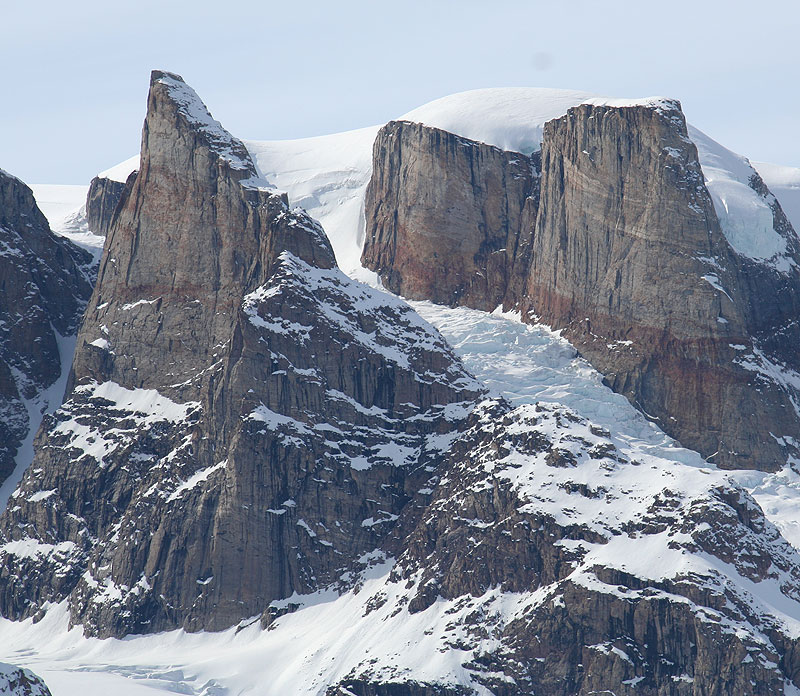
In the south of the island, the main pilgrimage site is the Schweizerland region, which offers ample opportunities for technical mountaineering and rock climbing, as well as big wall climbing, as demonstrated by the Fox Jaw Cirque above Tasiilaq Fjord, as well as the beautiful Tupilak peaks near the September 16 Glacier.
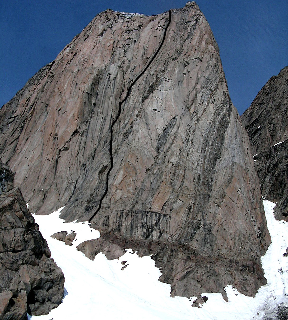
Several interesting and technically challenging routes to various peaks in the Schweizerland region are presented below. In the photo:


 - the route of the first ascent is shown")
The Staunings Alps area continues to attract alpine enthusiasts. All these trends remain in force, and at the same time, interest in the development of ski touring and ski mountaineering is growing. In the east and northeast of Greenland, there are still unclimbed and unexplored mountain ranges with thousands of unclimbed peaks. In the last few years, the first signs of development have been observed Winter mountaineering in Greenland. In March 2004, Paul Walker led a multinational team of climbers on the first-ever winter ascent of Gunnbjørnsfjeld, the highest Arctic mountain at 3,693 meters. They were forced to retreat due to temperatures of -40°C and strong winds literally blowing them off the ridge, but it was clear that winter ascents of many of Greenland’s peaks were only a matter of time. Indeed, in March 2006, Walker’s team successfully summited the mountain from the north. Therefore, although Greenland’s mountains lack the heights of the Himalayas or the Andes, their remoteness and Antarctic-like nature, as well as the prospect of first ascents, attract those seeking the spirit of exploration and expedition mountaineering in the 21st century.
Peaks in Greenland that are still planned for first ascents:
 |
 |
 |
 |
You can read about other areas of Greenland that are being developed today here.
Author of the article: Jim Gregson (Jim Gregson)
Source: Project ALP
This translation of the article is subject to the Copyright Law. Reproduction of this material on other resources is prohibited!