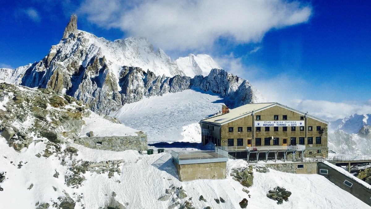
The Rifugio Torino hut is one of the key refuges on the border of Italy and France, in the Monte Bianco / Mont Blanc du Tacul massif, and is located at an altitude of 3,375 m. It offers the best views of the Géant glacier and the surrounding area.
The Rifugio Torino hut is located next to the Punta Helbronner (Skyway Monte Bianco) cable car station and serves as a base for climbers and tourists heading to the Glacier du Géantand the peaks of Dent du Géant, Aiguilles Marbrées, Mont Blanc du Tacul.

Official CAI hiking trails leading to Rifugio Torino (3,375 m):


🟥 CAI 20 – Pavillon du Mont Fréty → Rifugio Torino (via moraine and Géant glacier)

-
-
Start: Pavillon du Mont Fréty (2173 m)
-
📍 Coordinates: 45.8153 N 6.9389 E
-
-
Finish:Rifugio Torino Nuovo (3375 m)
-
📍 Coordinates: 45.8499 N 6.9455 E
-
-
-
Altitude gain: +1200 m
-
Length: ≈ 5 km
-
Time: 3–4 hours
-
Difficulty: EE (Escursionisti Esperti)
-
Terrain type: Alpine trail, moraine, snow and ice areas.
-
Dangers: Possible ice on the moraine in the morning, loose rocks, risk of rock slides during a thaw; snow and ice areas in the outer 300 m.
-
Equipment: trekking boots with hard soles, poles, helmet, light crampons if necessary.
-
Comment: The cleanest hike from Skyway; physically demanding, but without difficult technical sections.
🟦 Itinerario del Glacier du Géant (via Toula Glacier / Colle del Gigante)

-
-
Start: Passo del Gigante (3350 m)
-
📍 45.8508 N 6.9486 E
-
-
Finish: Rifugio Torino Vecchio (3375 m)
-
📍 45.8497 N 6.9450 E
-
-
-
Ascend/descent: ± 50 m
-
Time: 1 h
-
Difficulty:EEA (Ferrata / ghiacciaio)
-
Terrain type: glacier, crevasses, possible ice and snow bridges.
-
Dangers: hidden crevasses under the snow, need to move in a roped group, avalanche danger in snowfalls.
-
Equipment: Mountaineering equipment – crampons, ice axe, helmet, rope, harness.
-
Comment: Used as a short approach from glacier routes; strongly not recommended without ice experience.
🟩 Sentiero del Colle del Gigante (from Rifugio Monzino or La Visaille)

-
-
Start: Rifugio Monzino (2590 m) or La Visaille (1650 m)
-
📍 45.7647 N 6.8633 E
-
-
Finish: Rifugio Torino (3375 m)
-
📍 45.8499 N 6.9455 E
-
-
-
Elevation gain: +1800 m
-
Length: ≈ 10–12 km
-
Time: 7–8 h
-
Difficulty: F / PD (Facile – Peu Difficile, mountaineering category)
-
Type of terrain: Miage and Géant glaciers, snow fields, rock outcrops
-
Dangers: crevasses glacier, rockfalls during the day, rapid weather changes; Mandatory roped movement.
-
Equipment: Mountaineering (crampons, ice axe, helmet, harness, rope).
-
Comment: A classic route for experienced climbers, connecting the southern and northern flanks of Mont Blanc.
🟨 CAI 21 Traversata Punta Helbronner – Rifugio Torino is a high-altitude trail equipped with railings.

-
-
Start: Punta Helbronner (3450 m)
-
📍 45.8504 N 6.9458 E
-
-
Finish: Rifugio Torino (3375 m)
-
📍 45.8499 N 6.9455 E
-
-
-
Difference: –75 m
-
Time: 20–30 min
-
Difficulty: E (Escursionistico)
-
Terrain type: Mountain trail with stone steps and railings.
-
Hazards: Slippery areas when icy, strong winds, and low temperatures even in summer.
-
Equipment: Warm clothing, gloves, trekking boots.
-
Comment: This is a short but high-altitude trek—ideal for hikers arriving at the Monte Bianco Skyway.
🟣 Alta Via n. 2 – Variante Monte Bianco / Rifugio Torino (Alta Via 2 – Variante MB-TOR-01)

-
-
Start: Courmayeur (1224 m)
-
📍 45.7905 N 6.9721 E
-
-
Finish: Rifugio Torino (3375 m)
-
📍 45.8499 N 6.9455 E
-
-
-
Dial altitude:+2150 m
-
Time: 7–9 h
-
Difficulty: EE (Escursionisti Esperti)
-
Terrain type: combination of alpine trails, moraines, glaciers, and ridges.
-
Dangers: sharp elevation changes, fatigue, frequent fog, and snowfields on the final section.
-
Equipment: full trekking gear, if necessary Cats.
-
Comment: One of the most scenic, but difficult, approaches to Torino; offers magnificent views of the Dent du Géant and the Toula Glacier.
⚠️ General safety notes:
-
All routes above 2500 m require attention to weather conditions: fog, icing, and sudden cold snaps.
-
Sections above 3000 m often cross glaciers and snowfields—crampons and a roped team are required.
-
Best time for routes: July – mid-September (weather permitting).
For beginners, it’s best to start with Traversata Punta Helbronner → Rifugio Torino and use the Skyway cable car.
Official CAI routes to the Rifugio Torino hut: difficulty grades and characteristicsRifugio Torino: difficulty grades and characteristics
| Route | 📍 Starting point | ⛰️ Elevation Gain | ⏱️ Time | ⚙️ CAI / UIAA Category | ⚠️ Hazards | 🧭 Route characteristics | |
|---|---|---|---|---|---|---|---|
| CAI 20 | 🟥 Pavillon → Rifugio Torino | Pavillon du Mont Fréty (2173 m) | +1200 m | 3–4 h | 🟠 EE (Escursionisti Esperti) | Medium — loose rocks, ice on the moraine | The main hike from Skyway. An alpine trail over moraine and snowy areas. Excellent views of the Géant Glacier. |
| 🟦 Itinerary of the Glacier du Géant (via Toula) | Passo del Gigante (3350 m) | ±50 m | 1 h | 🔴 EEA (Ferrata/Ghiacciaio) | High — crevasses, hidden snow bridges | A short glacier trek. Requires crampons, rope, and experience climbing in a roped group. | |
| 🟩 Sentiero del Colle del Gigante (from Monzino / La Visaille) | Rifugio Monzino (2590 m) or La Visaille (1650 m) | +1800 m | 7–8 h | 🔴 F / PD (Facile / Peu Difficile) | Very high — crevasses, avalanches, rockfalls | The classic ascent on the Miage and Géant glaciers. Used by experienced climbers to cross the Colle del Gigante. | |
| CAI 21 | 🟨 Traversata Punta Helbronner → Rifugio Torino | Punta Helbronner (3450 m) | –75 m | 0.5 h | 🟢 E (Escursionistico) | Low — icing, strong winds | A short walk along a well-equipped trail between the Skyway station and Rifugio Torino. Ideal for beginners |
| Variante MB-TOR-01 | 🟣 Alta Via n.2 – Variante Mont Blanc | Courmayeur (1224 m) | +2150 m | 7–9 h | 🟠 EE (Escursionisti Esperti) | Moderate — fog, snow fields, fatigue | A long and panoramic route from the valley, connecting the Alta Via system with Rifugio Torino. Physically challenging, but picturesque. |


This article was written using official sources from Club Alpino Italiano (CAI), Tabacco Edizioni, and others:
- www.cai.it
- www.tabaccoeditrice.it
- geoportale.regione.vda.it
- www.montebianco.com/it
Source of material: alp.org.ua
Publishing this article on other resources is prohibited!