
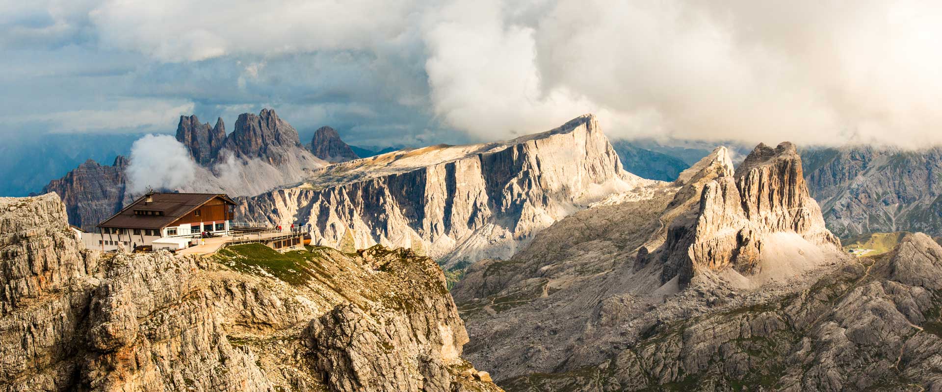
Rifugio Lagazuoi is a famous mountain hut in the Dolomites (Alps, Italy), at an altitude of 2752 m, popular among hikers and via ferrata enthusiasts. The main hiking routes to the Rifugio Lagazuoi vary in difficulty, ascent time, and scenic beauty.
Official routes to the Rifugio Lagazuoi (2752 m)
| Number and name | Route | 🏁 Start | 🎯 Finish | 📏 Length | ⛰️ Elevation gain | ⏱️ Time | ⚙️ Difficulty | 🔄 Type | |
|---|---|---|---|---|---|---|---|---|---|
| 🟥 CAI 401 | Sentiero del Lagazuoi | Passo Falzarego (2105 m) | Rifugio Lagazuoi (2752 m) | 3.5 km | +650 m | 1.5 – 2 h | 🟡 Average | Classic ascent, viewing platforms, Tofane panorama | |
| 🟧 CAI 402 | Sentiero Lagazuoi Nord | Col dei Bos (2331 m) | Rifugio Lagazuoi (2752 m) | 2.8 km | +420 m | 1.5 h | 🟡 Average | North slope, connects with route 20B | |
| 🟩 CAI 20 / 20B | Armentarola → Col dei Bos → Forcella Lagazuoi | Armentarola (1623 m) | Rifugio Lagazuoi (2752 m) | 8.5 km | +1150 m | 3.5 – 4 h | 🔴 Moderately difficult | The most picturesque, through the valley and forest | |
| 🟦 Via Ferrata Lagazuoi / Galleria Lagazuoi | Via Ferrata Lagazuoi | Passo Falzarego (2105 m) | Rifugio Lagazuoi (2752 m) | 2.5 km | +650 m | 2 – 3 h | 🔴 Complex | WWI Tunnels, Equipment Required | |
| 🟣 Giro del Lagazuoi (Circular Route) | CAI 401 → Rifugio Lagazuoi → 402 → 20B → back to Passo Falzarego or Armentarola | Passo Falzarego / Armentarola | Rifugio Lagazuoi (2752 m) | 9 – 10 km | +750 m | 4 – 5 h | 🟡 Average | Combination 401 → 402 → 20B, overview route |

Topographic map of the entire Monte Lagazuoi – Cinque Torri – Averau – Nuvolau area:
-
🟥 All main official CAI routes (401, 402, 419, 420, 439, and 441)
-
🟦 Main shelters: Rifugio Lagazuoi, Scoiattoli, Averau, Nuvolau
-
🟢 Lifts: Lagazuoi Funivia, 5 Torri Chairlift
-
🟡 Key points and passes: Passo Falzarego, Forcella Averau, Forcella Nuvolau
-
🔁 Possible circle routes between the huts

Official routes to Rifugio Lagazuoi
1. Sentiero CAI 401 – Sentiero del Lagazuoi
📍 Route: Passo Falzarego (2105 m) → Forcella Lagazuoi (2573 m) → Rifugio Lagazuoi (2752 m)
🧭 Type: Main ascent to the hut
⛰️ Character: Mountain trail of moderate difficulty. Elevation difference: ~650 m
🕓 Time: ~1.5–2 hours
💡 The most direct route to the shelter is 5 km

Route: You can hike up trail #401 or take the Lagazuoi cable car and then walk a few minutes to the hut.

It turned out to be circular because the route can be calculated as a variant Ascent and descent along different trails – namely:
-
ascent along Sentiero CAI 401,
-
descent along Sentiero CAI 407,
which actually form a loop between Passo Falzarego and Rifugio Lagazuoi.Start: Passo Falzarego (2105 m)
Finish: Rifugio Lagazuoi (2752 m)
🔹 Move Route
-
Start: From the parking lot and the cable car station at Passo Falzarego, look for the signs “Sentiero 401 – Rifugio Lagazuoi“. They are located right at the bottom station of the cable car.
-
First part of the route: The trail winds along a rocky slope, with occasional grassy areas. The slope is quite steep, but uniform.
-
Middle Section: More open rocky plateaus appear. From here you can see the walls of the Tofane, Cinque Torri and the Lagazuoi massif itself.
-
Final ascent: The last 200–300 m of altitude andThey go along rocky scree and steep serpentines. In some areas, there are wooden walkways and steps for convenience.
-
Finish: The trail leads directly to the Rifugio Lagazuoi, just above the upper cable car station.
⚠️ Dangers and Difficulties
-
A fairly steep climb in a short distance—unprepared hikers may tire quickly.
-
After rain, rocks and platforms become slippery.
-
Almost the entire trail runs along an open slope: it’s easy to overheat in sunny weather, and to lose your bearings in fog.
-
In summer, rockfalls are possible on some parts sections.
✅ Who is it for?
-
An ideal route for those who want to climb up on foot and avoid using the cable car.
-
Suitable for intermediate-level hikers (does not require mountaineering skills).
-
You can combine the two: climb up on foot, descend by cable car (or vice versa).
-
2. Sentiero CAI 402
-
📍 Route: Col dei Bos (2331 m) → Forcella Lagazuoi (2573 m) → Rifugio Lagazuoi (2752 m)
-
🧭 Type: Connecting trail. Travel time: 3-4 hours.
-
⛰️ Character: Rocky, runs along the northern slope.
-
💡 Used during the “Giro del Lagazuoi” circular route.

 via Forcella Lagazuoi")


-
Start: Hotel Armentarola (altitude about 1600 m), 46.549° N, 11.976° E
- Start: Armentarola (about 1,600 m, near Hotel Armentarola)
- Finish: Rifugio Lagazuoi (2752 m)
- Elevation difference: ~1,150 m
- Length: 8–10 km
🔹 Route progress
-
Armentarola (start at Hotel Armentarola, 1,600 m)
From the hotel and parking lot, take the SP24 road (Via Valparola). Here is a sign with red and white markings CAI 20 (Forcella Lagazuoi / Rifugio Lagazuoi). -
Forest section (1,600–1,900 m)
The first kilometers of the trail go through a pine forest, on a soft dirt road. Here the slope is moderate, with streams and small bridges. -
Alpine meadows (1,900–2,200 m)
After leaving the forest, open panoramas of the Val Badia valley begin. The trail becomes rockier, with switchbacks going up. -
Ascent to Forcella Lagazuoi (2,573 m)
The hardest part Route: A long, rocky climb with a steep climb. Strong winds are common here. The pass offers views of Tofane, Conturines, and Marmolada. -
Final section (Forcella Lagazuoi → Rifugio Lagazuoi)
From the pass, the trail turns south and emerges onto the Lagazuoi ridge. The last 200 m of the climb are along rocky slopes, after which the trail emerges directly onto the Rifugio Lagazuoi.
⚠️ Dangers and Difficulties
-
Physical Activity: Long, steady climb, requires good endurance.
-
Fog and clouds: Visibility may be severely reduced, especially near the pass.
-
Scree and rocky areas: Caution is required when ascending and descending.
-
Weather: Windy and a sharp drop in temperature on Forcella Lagazuoi.
✅ Who is it for?
-
For experienced hikers in good physical condition.
-
For those who want to take the historical route (there are positions and galleries from the First World War in the area of the pass) War).
-
An excellent choice in summer for those who want a long and scenic climb without using a cable car.
How to find the trail to Rifugio Lagazuoi from the Armentarola Hotel
-
From the hotel entrance/parking lot, take the road (Via Valparola / SP24) that leads to the Passo Valparola.
-
After 100–200 m, there will be trail signs (usually red and white, with route numbers).
-
You need trail No. 20 (Armentarola → Forcella Lagazuoi).
-
This trail initially goes through forest and alpine meadows.
-
It then emerges onto a rockier slope.
-
The climb is quite long, but well marked.
-
-
Trail #20 connects with Trail #401, which leads directly to Rifugio Lagazuoi.
-
Option: you can make a loop via Col dei Bos if you want more Long route (trail #20b, then exit at #402 and 401).

3. Via Ferrata Lagazuoi / Galleria del Lagazuoi
-
📍 Route: Passo Falzarego → Galleria Lagazuoi → Rifugio Lagazuoi
-
⛰️ Type: Historical Via ferrata, passes through WWI tunnels and steep slopes.
-
⚠️ Via ferrata equipment required (helmet, harness, headlamp).
-
💡 One of the most famous historical routes in the Dolomites.
, hiking trail (blue)")
🗺️ Route legend:
| Line color | Designation | Description |
|---|---|---|
| 🔴 Red dotted line | Via Ferrata Lagazuoi | The main climbing route along the rock face with metal cables and steps. Starts at Passo Falzarego (2105 m), passes through Galleria Lagazuoi (World War I tunnels) and climbs to the summit of Monte Lagazuoi, ending at Rifugio Lagazuoi (2752 m). |
| 🔵 Blue dotted line (CAI 402) | Sentiero CAI 402 Hiking Trail | An alternative trail for ascending or descending without using the via ferrata. It connects Forcella Lagazuoi (2573 m) with Rifugio Lagazuoi and can be used for returning after completing the via ferrata. |
| 🟡 Yellow Line | Passo Falzarego Road | The main road SP24, leading over the pass and to the lower station of the funicular Lagazuoi Funivia. Not part of the walking route. |


-
Start: Passo Falzarego pass (2105 m)
-
Length: ~2 km
-
Travel time: 2–3 hours with stops
4. Sentiero CAI 20 / 20B
-
📍 Route: Armentarola (1623 m) → Col dei Bos (2331 m) → Forcella Lagazuoi → Rifugio Lagazuoi
-
⛰️ Character: A long, scenic climb from the north. Duration: 9–10 km, walking time: 3.5–4.5 hours
-
💡 A very popular route among hikers, especially in summer


-
The route from Armentarola via Col dei Bos to Rifugio Lagazuoi does not have a single number; it consists of a series of trails:
-
Sentiero CAI 20B (Armentarola → Col dei Bos)
-
Sentiero CAI 402 (ascent via Col dei Bos)
-
and the final section on Sentiero CAI 401 (to Rifugio Lagazuoi).
-
Start: Armentarola (approx. 1,600 m, near Hotel Armentarola, San Cassiano, Val Badia)
Finish: Rifugio Lagazuoi (2,752 m)
Elevation difference: ~1,150 m
🔹 Route Progress
-
Armentarola (start, 1,600 m)
– Start at Hotel Armentarola (there is parking and a bus stop).
– Signs indicate: Sentiero CAI 20B (Col dei Bos / Lagazuoi).
– The first kilometers are along a forest road and paths, then you reach open meadows. -
Ascent along Sentiero 20B (up to 2000 m)
– The trail goes through the forest and then emerges onto rocky slopes.
– Gradual climb, in places along serpentines. -
Col dei Bos (approx. 2,200–2,300 m)
– The saddle of the Col dei Bos massif is reached.
– Panoramas of the Tofane, Cinque Torri, and the Falzarego Valley.
– Here Sentiero 20B joins Sentiero 402. -
Ascent along Sentiero 402 (2,200–2,500 m)
– Steeper section, serpentines along rocky slopes.
– Along the way, you will see the remains of fortifications from World War I.
– Exit to a fork with Sentiero 401, leading directly to Rifugio Lagazuoi. -
Final section along Sentiero 401 (2,500–2,752 m)
– Steep but well-marked climb.
– The trail reaches a plateau near the upper cable car station and the Rifugio Lagazuoi.
⚠️ Dangers and Difficulties
-
Long route with bigGreater elevation change → requires good endurance.
-
The slope of the Col dei Bos massif is rocky, loose, and rock falls are possible.
-
In bad weather (fog, rain), orientation is difficult.
-
In summer, the sun is strong, and almost the entire trail runs in the open relief.
✅ Who is it for?
-
For trained hikers who want to take a beautiful and historically rich route.
-
For those who prefer a wilder and less popular climb than the classic Sentiero 20 via Forcella Lagazuoi.
-
Great for history buffs—along the way, trenches and positions from World War I remain.
5. Giro del Lagazuoi (Circular Route)
-
📍 Combined Route: CAI 401 → Rifugio Lagazuoi → 402 → 20B → back to Passo Falzarego or Armentarola
-
⛰️ Type: Circular Route
-
🕓 Time: ~4–5 h
-
💡 A popular “classic” route around Monte Lagazuoi

Explanation:
-
Sentiero del Lagazuoi – “Trail Lagazuoi (Italian name).
-
Giro del Lagazuoi — “Circular route around Mount Lagazuoi”.
-
CAI 401 — route number according to the classification of the Italian Alpine Club (Club Alpino Italiano).
-
This route is sometimes referred to as part of Alta Via 1, but the circular route around Lagazuoi has its own designation, CAI 401.
-
Start/End: Passo Falzarego
-
Itinerary: You can make a loop through Rifugio Lagazuoi, ascending on foot or via ferrata, then descend along trail no. 401 to Passo Falzarego.

Beginning of the route
-
Starting point: Ascent to Lagazuoi from Passo Falzarego
-
Access: You can ascend by Lagazuoi Funivia funicular (recommended for savings)(or time) or on foot from Passo Falzarego (additional ~1–1.5 hours of ascent).
Length and Elevation Gain
-
Length of the circular route: approximately 6–8 km (depending on the option)
-
Elevation Gain: ~400–500 m in a circle
-
Completion time: 3–4 hours at a leisurely pace
Route description
-
Start from the upper funicular station or Passo Falzarego.
-
Ascent along the CAI 401 trail to the summit of Lagazuoi (viewpoints, old military tunnels from World War I).
-
Circular Bypass: The route goes around the summit, combining mountain trails and historic military trails, with stunning panoramas of the Dolomites.
-
Descent: Return to the starting point of the funicular or Passo Falzarego.
Difficulty
-
Moderate: Requires confident walking on a mountain trail and some rocky areas.
-
Does not require technical Mountaineering, but there are sections with small rocky ascents and descents.
✅ General safety tips for all routes:
-
Sturdy shoes with hard soles are required.
-
At least 1.5 liters of water per person.
-
Lightweight warm clothing + raincoat (weather changes quickly).
-
For the via ferrata — only with insurance!
-
It’s better to start in the morning to descend before dark.


General map—the entire Monte Lagazuoi area with the CAI 401, 402, 20/20B, Via Ferrata Lagazuoi, and Giro del Lagazuoi trails:

Main data sources used in the material:
-
Main sources and databases:
1. Club Alpino Italiano (CAI) — Italian Alpine Club
-
Source of official trail numbers (e.g. Sentiero CAI 401, 402, 20/20B).
-
Used in the original CAI system for the Veneto and Trentino-Alto Adige regions.
-
Data includes altitude, start/end points, distance, and difficulty classification.
📘 Official website: www.cai.it
-
2. Tabacco Map Series 1:25 000 — Foglio 07 “Cortina d’Ampezzo e Dolomiti Ampezzane”
- Used for plotting routes, trail coordinates, and topographic relief.
📘 Publisher: Tabacco Editore, Udine, Italy
📖 Maps: Foglio n.07 – “Cortina d’Ampezzo e Dolomiti Ampezzane”
3. GeoPortale Nazionale & OpenTopoMap
- Used in CAI/Tabacco cartographic visualization.
📘 Source: geoportale.cai.it
4. Official tourist websites and guides:
5. Historical and tourist sources:
-
“Le Vie Ferrate delle Dolomiti” — Guido Scalet, Ed. Zanichelli
-
“Dolomiti Ampezzane – Carta dei Sentieri CAI” (CAI Sezione Cortina d’Ampezzo, 2022)
Source of material: alp.org.ua
Publishing this article on other resources is prohibited!