
This area is not new, mountain tourists have been exploring it for about 20 years, mainly in the form of hikes in May or early summer. You can find many reports on the Internet. Aladaglar is the most developed mountain region in Turkey for climbers, although most descriptions and guidebooks are only available in Turkish.
Parmakkaya is one of the calling cards of Aladaglar. The classic route is approximately 4A.

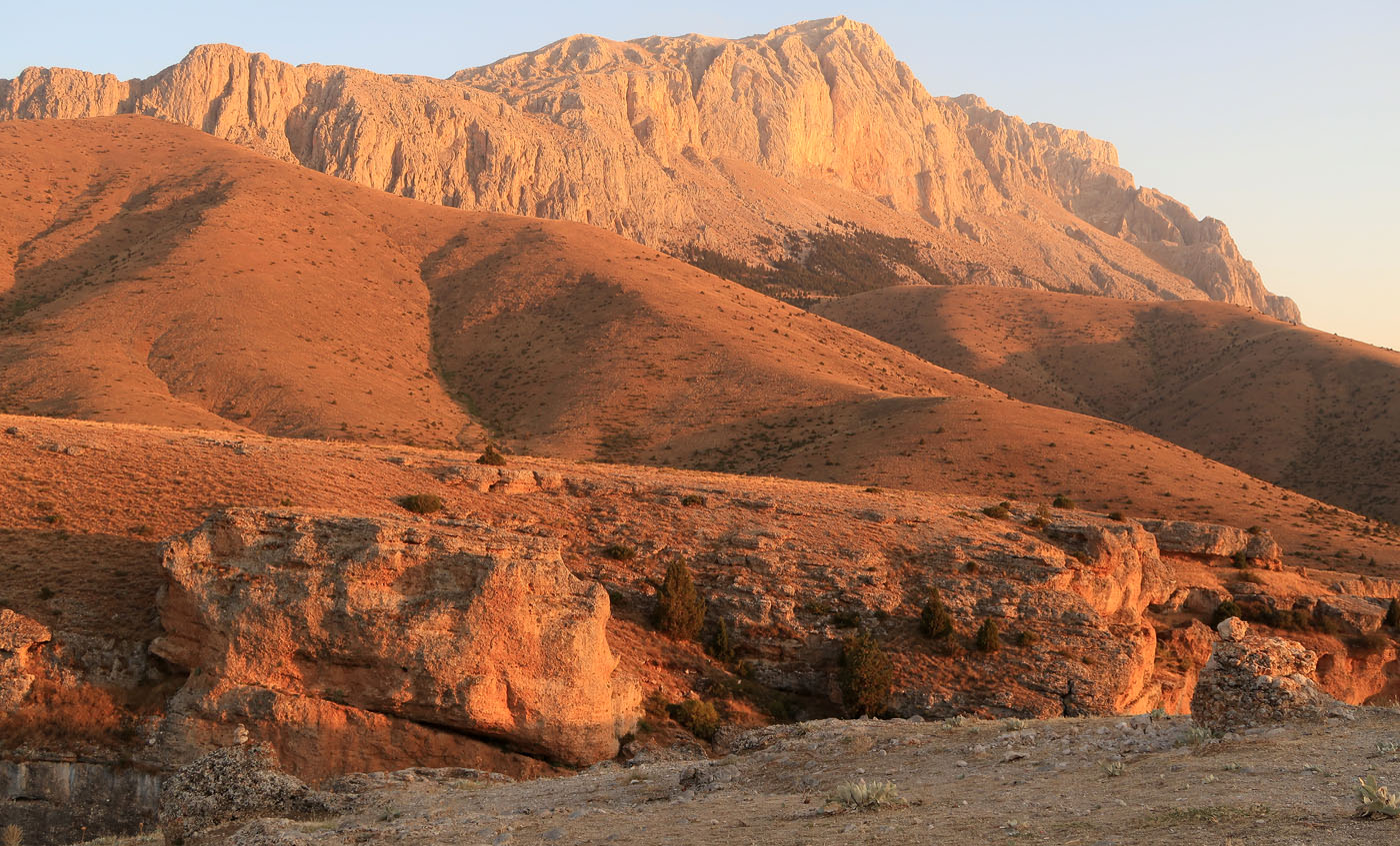
The main ridge of Aladaglar extends from north to south for about 30 km, and south of the Emli Valley turns to the west. More gentle side ridges go to the east. The mountains are composed of limestone, the height of the central ridge is up to 3771 (Kizilkaya Mountain). Until recently, Demirkazyk was considered the highest point, after more accurate measurements its height is 3756.
Conventionally, Aladaglar can be divided into 3 parts, the most interesting is the central one, from the top of Sarsal in the north to Guzeler in the south. The highest peaks and rock walls are located here.
Climbing routes – for every taste: there are easy ones to almost all the peaks, and traverses; there are rock walls with 10-20 ropes; in winter – combined routes with snow. There is no permanent glaciation. At the beginning of autumn there is almost no snow, but we found a couple of snow-covered couloirs in the shade and small snowfields under the northern walls.

The easiest access to the area is from the west, from the route leading to Chamardi. The mountains can be divided into three levels: rock climbing sectors in canyons (up to 2000 m), multi-pitches and short rock routes on the side spurs (2300-2700 m), and higher – the actual climbing routes.
Guidebooks
Rock Climbing Guide To Aladağlar. Guidebook to the Sport routes in Kazıklı Valley and Cimbar Valley alongside the Alpine and Alpine Sport routes of the Aladağ Mountain Range. (Recep İnce / English / Turkish / 2007). We bought it on Amazon, the climbing routes are well described (in Turkey this category includes both multi-pitches and trad). The few rock alpine routes are described briefly and inaccurately. Recep, the author of the guidebook, is the author of many climbing routes and the owner of one of the campsites.
50 Climbing Routes in The Aladağ Range Guidebook with a selection of ridge routes, long trad routes and ice & mixed climbing in the Aladağ Mountain range. Includes detailed map of the Mountain Range. (Tunç Fındık / English /2011). An old guidebook by Tunç Fundık (leading Turkish mountaineer).
ALADAĞLAR MOUNTAIN AND CLIMBING GUIDE. New guidebook by Fundyk, describes almost 500 routes. I managed to buy only in Turkish, but this is probably the most comprehensive and quite detailed guide to the Aldaglar alpine routes. It also comes with a large and detailed ridge map.
Among the sites with route descriptions (in Turkish) and photographs, we can mention: http://www.dursunsimsek.com/category/dag-etkinligi/aladaglar
Maps
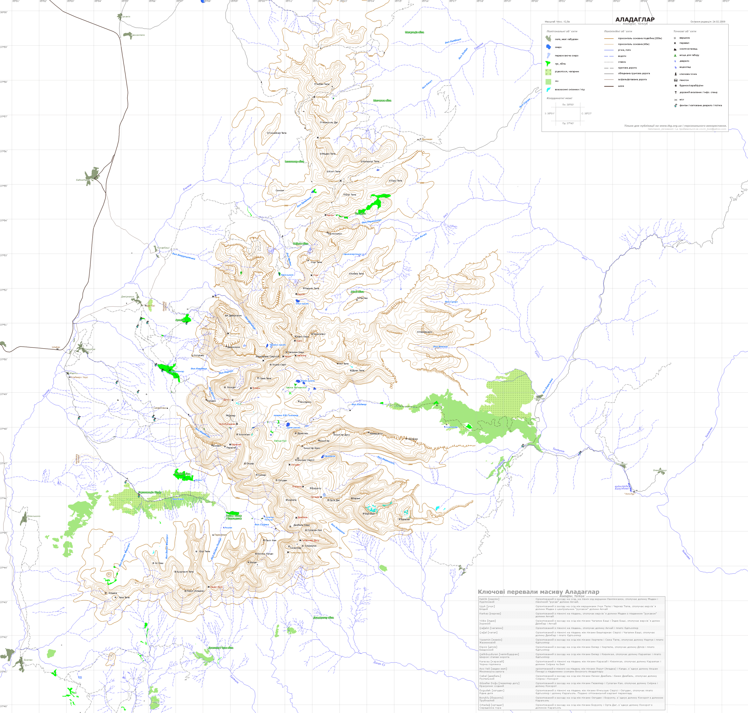
In Turkey, topographic maps are not publicly available, so there are no normal printed maps. In OSM, its various clones, the data is incomplete. Of the maps available on the Internet, there are:
Scheme-ridge by Tunc Findik, the correct names of objects, springs and parking places are shown, but the map itself is very approximate:

Water sources and campsites
Map of the ridges, some passes are shown:
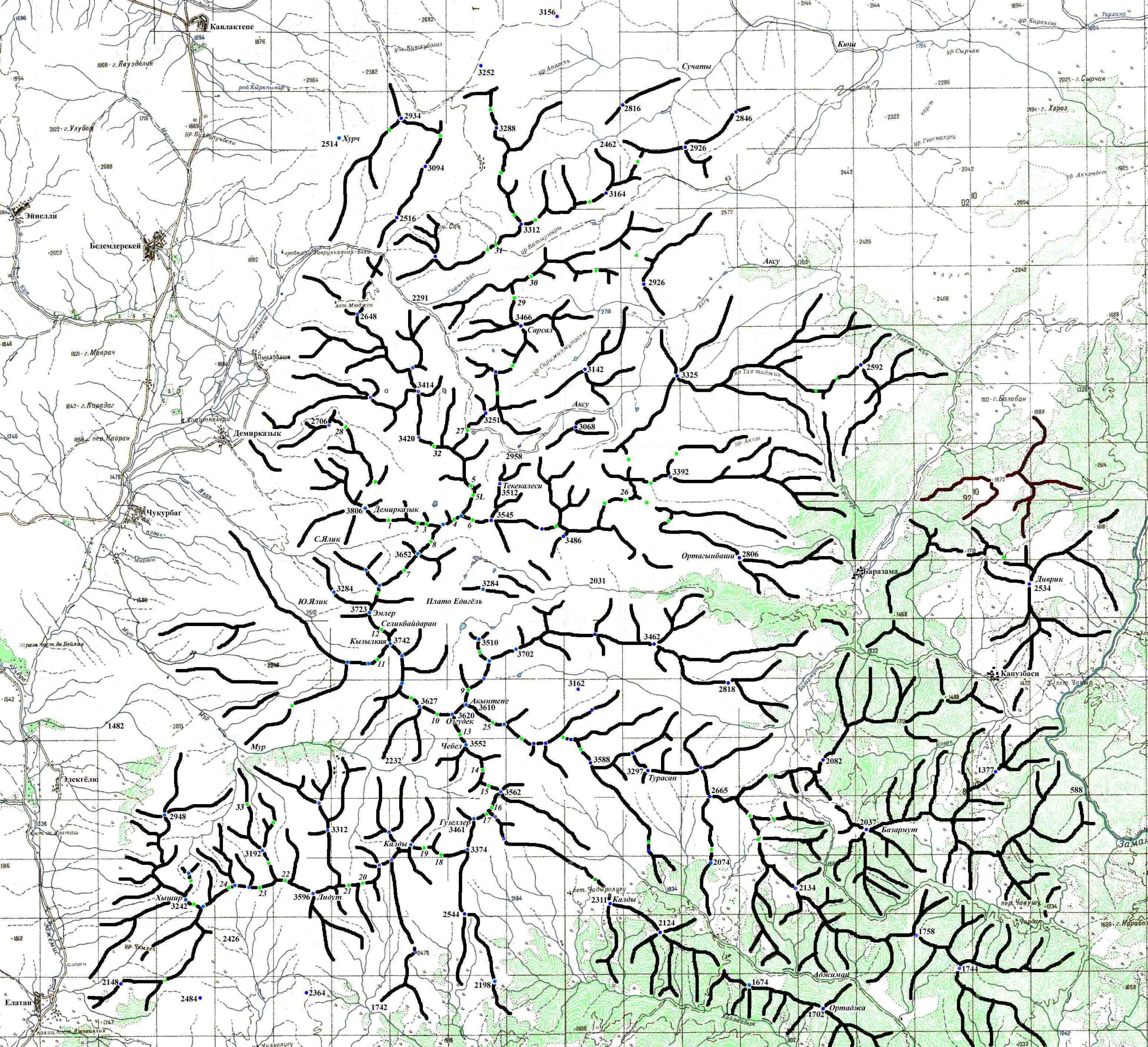
The ridge with topography, but not all objects are shown (photo in high resolution):

Logistics
The nearest points with airports are Kayseri and Adana. Sometimes they fly to Ankara – it’s another 7 hours by car. Then either rent a car – this gives greater mobility, since many locations, especially rock climbing, are accessible by car. Or get there on your own – public transport works well in Turkey. From Kayseri, the route is as follows: Kayseri – Nide, Nide – Chamardi and then by taxi.
We did not rent a car, but we always agreed on a transfer without any problems. Hitchhiking works – several times, on the way from rock climbing locations to the campsite, we were given a lift.
We bought gas at Decathlon in the Kayseri Park shopping center.
In supermarkets in large cities, a “standard” set of products is available plus Turkish specifics – sweets, olives, etc. We did not find edible sausage. We brought dry food and freeze-dried food, and the aforementioned sausage. Alcohol, especially strong alcohol, is also cheaper to bring with you. In small villages the choice is simpler, but the basics are there: sweets, cheese, fruits/vegetables, bread, beer (not in every store), etc.
In many places you can pay with a bank card, but not everywhere. The further into the hinterland – the more cash you need. You will have to pay a commission for both exchange and for withdrawing money from an ATM. In Chamardi we found the only ATM.
You can base yourself in one of the villages – Marti, Chukurbeg, Demirkazyk, which are located along the road that runs parallel to the main ridge – from north to south.
Optimal locations – camping (Aladaglar Camping Bungalow), and the Turkish Alpine Federation shelter in Demirkazyk – Demirkazik Mountain Hut (DMH).
There is also a hostel in Çukurbeg. Recep Ince is the author of many climbing routes in Aladaglar, as well as the author of a climbing guidebook. In all the listed camps, you can live in tents or in a bungalow/shelter building. There is a kitchen with gas, shower, Wi-Fi, etc.
From Recep’s camp closer to the Emli valley and the Kazikli canyon, from the DMH shelter – everything in the area of the Demirkazyk, Emler peaks and the Chimbar canyon is accessible. You can get to the climbing sectors directly from the campsites by car or on foot, if you are planning on alpine climbing – you need to move to higher campsites, or climb even higher on foot – to the parking lots in the upper reaches of the valleys.
At first we lived with Recep, then moved to DMH.
The peculiarity of Aladaglar is that the area is dry and water sources (and, accordingly, places for camping) are few and far between, especially in late summer and autumn. Also, most of the area is a national park. You have to pay, in my opinion, a symbolic fee for visiting and parking on the territory of the national park.
In fact, there are several parking lots available for cars with equipped springs and more or less equipped places for tents (the altitude is on average about 2000 m above sea level). Sometimes there are shepherds’ pens nearby – with all the accompanying sheep, dogs and flies.
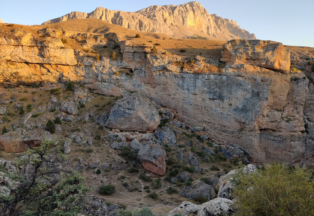
In the central part of Aladaglar, such parking lots are Sarimemetler at the beginning of the Emli valley, as well as Sokolupinar and Kayacik west of the Demirkazyk and Emler peaks. Also in the upper reaches of the Chimbar canyon is the Arpalik plateau, which is essentially a source of water and nearby meadows, where sheep and shepherds are based during the summer.

Arpalick plateau (there is an equipped spring, but there is no equipped place for tents).
. In the clearing on the pass on the right side of the frame you can see a car (not ours) and an orange tent (ours). On the left is the upper reaches of the Chimbar canyon.")
Higher in the mountains, the campsites are tied to natural water sources, some of which are seasonal.
Another important factor is the sun, which is very hot even at the end of September. Therefore, an important factor when choosing a route or climbing sector is its exposure. Pay attention to “morning shade”, “all day shade”, etc. in the descriptions.
Rock Climbing
In the developed part of Aladaglar, there are three main rock climbing locations, all in canyons – Kazikli Canyon, Chimbar and Pinar-bashi Canyons near DMH.

The canyon has over 20 sectors and over 300 climbing routes, mostly fr6-fr7. There are a few 8k, for example in the Podium sector. There are also a number of trad routes. We climbed there for 2 days, mainly in the Carnival and Cankule sectors, tried a couple of the easiest routes on the Podium. Carnival is good for a warm-up – a lot of sixes, is in the shadow until 2-3 pm.
On the right is the beginning of the Carnival sector.
Chimbar Canyon. First of all, it is just a huge canyon with two sources, one of which (the right or.) comes almost from under Demirkazyk itself. Both sources are passable, along the bottom there is a path with small underpasses. There is water only in a separate section at the right (northern) source of the canyon.
Chimbar Canyon, its left part, from the Arpalick plateau. Below you can see the turn of the road – there is the lower entrance to the canyon.

The entrance to the canyon is from below – right from the road, half a kilometer from DMH. There are about a dozen climbing sectors in the Chimbar Canyon, but they mostly didn’t impress us. The main interest is in the multi-pitches, of which there are a couple dozen – there are fully equipped ones, and purely trad ones, and combined ones (partly equipped), where in addition to the bolts you need your own insurance.
There are also several caves, or rather grottoes. Kizil Catlak Cave with three routes, described in the guidebook. And we also found a grotto with 2 routes, which are not in the guide.

Pinarbaşı Canyon is another canyon not far from DMH. It takes about an hour to walk along the road towards the village of Pinar. Of the three locations where we climbed in Aladaglar, this one made the brightest first impression. A narrow canyon with high, steep walls, there is almost always shade there.

The routes here are long, we got a bit confused and among other things climbed Belinda, which is 34 m long – we had to leave the rapid on the descent. 44-meter Kill me softly. There are also trad lines and even multi-pitch. There are practically no simple lines (6a and less).
Multi-pitches
In addition to the mentioned multi-pitches in canyons, there are multi-pitch routes on separate walls and even peaks. In Recep’s guidebook, they are in the “mountaineering” category, so you need to look at the description, paying attention to the bolting. In our terminology, multi-pitches usually mean a route at least partially bolted with bolts (fully equipped or partially equipped). The difficulty is varied – from 150-meter routes with 6a on the key, to a 650-meter route on Demirkazyk with an 8a key.
Teke Pinary Towers – two easy routes (up to 6a), but with the need for additional belay with your own points. A great option for a warm-up.

Kayachik Towers – there are already 3 routes to it (one is described in the guidebook), the length is 250 m. with a key up to 7a in the upper part. Unfortunately, shade only in the morning.

Mountaineering
As already mentioned, there are several hundred climbing routes in Aladaglar, and there is potential for first ascents. We focused on rock routes of medium difficulty (D – TD in the alpine classification). It should be borne in mind that in Turkey the difficulty of individual sections and the entire route is given in open UIAA categories (Roman numerals) – not to be confused with the closed post-Soviet classification, also Roman, but the maximum category there is VI. For those unfamiliar, VII- looks scary, although in fact in climbing it is about 6a+. For popular routes, the descriptions sometimes also give an alpine category.
We tried to choose popular and relatively easily accessible lines.
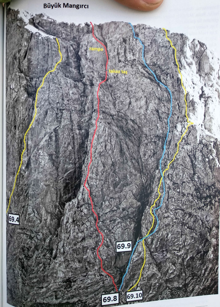
In the Emli Valley we went from the Sarimemetler campsites, climbed the classic route to Parmakkaya (Finger Rock), and two routes along the northern wall of Mangirci – Mangirci Diedral (69.8) and Hasat Zamani (69.4).

In the Demirkazyk area we climbed to the campsites at the Dipsiz Göl lake – there was no water below the kosh. Dipsiz Göl translates as “bottomless lake”, and in autumn its name sounds somewhat ironic.

Our main goal was the classic on the northern wall of Demirkazyk. Before that, I decided to go to some simpler koroloche, having randomly chosen the route to Beshbarmak (Beshbarmak/Beshparmak – five fingers) in the guide – 6 ropes with the VII- key. It turned out to be a terrible wreck, we climbed the key, but did not go to the top – we rappelled along the way.
There are several peaks around Dipsis-Gol, which break off to it with rocky walls – there is plenty of room to roam. The peaks are Chagalin basy – Beshparmak – Kojasarp (from left to right).
")
Overall, I really liked the area – a wide variety of routes, good logistics and Turkish flavor.
Based on materials from: livejournal.com